Connects: Alaska Highway, YT, to Alaska Highway, AK
Routes#: Yukon 2 & 9, Alaska Route 5
Length: 498 miles
Road Surface: Pavement, seal coat & gravel
Season: Hwy. 2 open all year, Hwys. 9 and 5 closed in winter
Maps (2 detailed pdf files available):
Milepost J 0 to Milepost J 292 (includes Silver Trail)
Milepost J 292 to Tetlin Junction, Alaska Highway
Alaska-bound motorists taking the Klondike Loop turn off the Alaska Highway about 8 miles north of Whitehorse and follow the Klondike Highway (Yukon Highway 2) 323 miles/520 kms to Dawson City; then take the George Black free ferry across the Yukon River and drive 79 miles/127 km west via the Top of the World Highway across the international border into Alaska via the Boundary Spur Road; and finally take the Taylor Highway 96 miles/154 kms south to where it joins the Alaska Highway near Tok. Driving the Klondike Loop adds about 102 miles compared to just driving the Alaska Highway; it is a popular inbound and outbound route.
All of Klondike Highway 2 between the Alaska Highway junction and Dawson City is asphalt-surfaced and in fair to good condition with some damaged pavement and occasional gravel breaks. Top of the World Highway includes the 66-mile/106 km Yukon Highway 9 on the Canadian side which is seal-coated (with potholes and gravel breaks), then 13 miles of pavement topping Alaska’s Boundary Road west from the U.S.-Canada border. The Taylor Highway north to Eagle and south to Chicken from its junction with Boundary Road (at Jack Wade Junction) is a narrow, winding, dirt and gravel road with little or no shoulder. From Chicken south to the Alaska Highway, the Taylor Highway is chip seal and pavement with many damaged sections. Drive with headlights on at all times and yeild to oncoming large vehicles on curves.

The Taylor Highway and Boundary Spur Road/Top of the World Highway are not maintained in winter and snow effectively closes these roads from mid-October until April and mid-May. Alaska Dept. of Transportation crews generally plow the Taylor Highway to Eagle in early April. The Boundary Spur/Top of the World Highway to Dawson City, YT, remains closed until U.S./Canadian Customs opens in mid-May. Opening of the international border is dependant on the breakup of the Yukon River at Dawson City and the resumption of ferry service. Closing of the international border usually occurs around the third week in September, but phone the Dawson City Visitor Centre at 867-993-5566 and double-check before attempting to drive this road in the fall.
Yukon Highway 2 is open year-round (Alaska Highway junction near Whitehorse to Dawson City). Drive with headlights on at all times and watch for wildlife.
Communities
Miles from Alaska Highway junction (J) near Whitehorse is followed by miles from Dawson City (D). NOTE: Physical kilometreposts show distance from Skagway.
J 0 D 323.4 Junction with the Alaska Highway at Milepost DC 894.5, 7.4 miles northwest of the Two Mile Hill turnoff to downtown Whitehorse.
J 3.6 D 319.8 Junction with Takhini Hot Springs Road; gas bar. Attractions on this side road include Yukon Wildlife Preserve and Takhini Hot Springs Campground and Hostel.
J 9.8 D 313.6 Sundog Retreat, right on Policeman Point Road; cabins.
J 20.3 D D 303.1 Lake Laberge Yukon government campground.
J 34.5 D 288.9 Fox Lake Yukon government campground.
J 55.2 D 268.2 Braeburn Lodge phone 867-456-2867; food, gas, diesel, lodging. Home of the World Famous Cinnamon Buns.
J 71.9 D 251.5 Twin Lakes Yukon government campground.
 J 80.6 D 242.8 Rest area at remains of Montague House, an early-day roadhouse (pictured above).
J 101.5 D 221.9 CARMACKS (pop. 539; all services. Visitor information. Lodging, restaurant, gas, diesel and RV park at Hotel Carmacks and Tatchun Centre. Attractions include restored Carmacks Roadhouse.
J 103.5 D219.9 Junction with the Campbell Highway to Faro, Ross River and Watson Lake.
J 116.3 D 207.1 Five Finger Rapids Recreation Site to west; large double-ended parking area with picnic table, hiking trails, toilets litter bins and viewing platform.

Five Finger Rapids was named by early miners for the 5 channels or fingers formed by the rock pillars.
J 117.9 D 205.5 Tatchun Creek Yukon government campground.
J 118.5 D 205 Turnoff for Frenchman Lake Road to Tatchun Lake Campground (5.2 miles), Nunatuk Campground (20.7 miles) and Frenchman Lake (26 miles).
J 125.5 D 197.9 Yukon Crossing Viewpoint rest area.
J 146.6 Access west to Minto Resort, open mid-May to mid-Setpemebr, located on the banks of the Yukon River. A regular lunch stop for tour buses, there is a rustic campground for independent RV travelers.
J 167.8 D 155.6 PELLY CROSSING (pop. 296); grocery store, gas, lodging, bank and post office at Selkirk Center, phone 867-537-3031. RV camping (no hookups) at Pelly River Campground. First Nations heritage at Selkirk Heritage Center, a replica of the Big Jonathon House at Fort Selkirk.
J 168 D 155.4 Pelly River Bridge and Pelly River Crossing Yukon government campground to west.
J 168.8 D 154.6 Viewpoint of Pelly Crossing and river valley.
J 205 D 118.4 Ethel Lake Yukon government campground.
J 211.6 D 111.8 Stewart Crossing; gas, diesel.

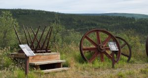
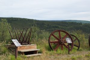
J 212.2 D 111.2 Junction with Yukon Highway 11 (Silver Trail) to MAYO (pop. 450), with food, gas, diesel, groceries; lodging and camping at Bedrock Motel & RV Park; Visitor information at historic Binet House (pictured above). Additional historic attractions on the Silver Trail include the frontier mining town of KENO CITY (pop. 20) at the end of the road. Keno City Hotel offers lodging, restaurant and bar. Visit Keno City Mining Museum to see tools and equipment used in the early days of mining in this area.
J 226.7 D 96.7 Moose Creek Lodge; food, lodging.
J 227.1 D 96.3 Moose Creek Yukon government campground.
J 298.3 D 25.1 Junction with Dempster Highway to Inuvik; AFD public cardlock gas station with diesel.
J 311.7 D 11.7 Klondike River Yukon government campground.

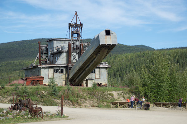
J 321.2 D 2.2 Junction with Bonanza Creek Road. Access to Claim 33 Gold Panning (Mile 6/9.6 km); Dredge No. 4 National Historic Site at Mile 7.4/12 km (pictured at left), is the largest wooden hulled bucket line gold dredge in North America; Discovery Claim National Historic Site, Mile 8.8 mile/14.2 km, has a walking trail with information boards describing the story of the gold discovery; and Claim No. 6, at Mile 9.4 mile/15.1 km, which has public gold panning (bring your own pan).
J 321.3 D 2.1 Bonanza Gold Motel & R.V. Park; lodging, camping.
J 321.4 D 2 Dawson City RV Park and Campground and gas station; camping, gas, diesel, tire repair.
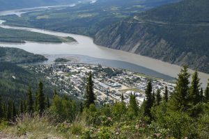
J 322 D 1.4 Dome Road leads 4.5 miles to Midnight Dome viewpoint of Dawson City and the Yukon and Klondike rivers (pictured below).

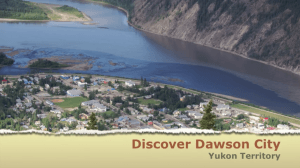
J 323.4 D 0 DAWSON CITY (pop. 1,879); all services. Visitor information. : Visitor Center, open daily, at the corner of Front and King streets. Dawson City is a National Historic Site and offers visitors a unique opportunity to relive Yukon’s gold rush days.

Major attractions in Dawson City include: SS Keno National Historic Site, Dawson City Museum, Jack London Museum, Robert Service Cabin. Accommodations at Downtown Hotel, The Eldorado Hotel, Klondike Kate’s Cabins & Restaurant, Midnight Sun Hotel, Bonanza Gold Motel, Westmark Inn. Souvenirs, books and more at Maximilian’s Gold Rush Emporium on Front and Queen streets. Lectures, concerts, art exhibits and more at the Klondike Institute of Art & Culture, on the corner of Second Avenue and Princess Street. Camping at Gold Rush Campground RV Park, Dawson City RV Park & Campground and Bonanza Gold RV Park.
Miles from junction with the Alaska Highway near Whitehorse (J) is followed by miles from Dawson City (D) is followed by miles from Tetlin Junction (TJ). Tetlin Junction is the junction of the Taylor Highway with the Alaska Highway.
J 323.4 D 0 TJ 175 Entrance/exit at end of First Ave./Front Street in Dawson City for George Black passenger/vehicle ferry (pictured below left) across Yukon River to/from Top of the World Highway (Yukon Highway 9) west to Alaska. This free government ferry operates from about mid-May to mid-October.

J 323.6 D 0.2 TJ 174.8 Yukon River Yukon government campground.
J 389.1 D 65.7 TJ 109.3 U.S.–Canada Border. U.S. Customs (Poker Creek) and Canada Customs (Little Gold Creek) joint border crossing facility operates seasonally from about mid-May to mid-September. Check with the Visitor Information Centre in Dawson City, YT, about border opening if you are traveling in the shoulder seasons.
J 389.7 D 66.3 TJ 108.7 Davis Dome Wayside; beautiful views.
J 393 DJ 69.6 TJ 105.4 Historic Boundary Roadhouse, which dates from about 1926, was one of the first roadhouses in Alaska.
J 402.9 D 79.5 TJ 95.5 Jack Wade Junction. Junction with Taylor Highway (Alaska Route 5), which leads north to EAGLE (64 miles) or south to Chicken (28 miles) and continuation of Klondike Loop to junction with the Alaska Highway just east of Tok at Jack Wade Junction. Eagle, on the Yukon River, offers accommodations at the Falcon Inn B&B and camping at Eagle BLM Campground. Attractions include Fort Egbert and the Wickersham Courthouse, built in 1901.

J 416.4 D 93 TJ 82 Walker Fork BLM Campground to west at north end of Walker Fork Bridge
J 423.2 D 99.8 TJ 75.2 South Fork River Wayside; picnicking, outhouses.
J 431.5 D 108.1 TJ 66.9 Town of Chicken/The Gold Panner/Chicken Creek RV Park, Cabins & Ensuite Rooms; cafe, gas, diesel, camping, cabins, souvenirs.
J 432D 108.6 TJ 66.4 CHICKEN (pop. 23 in summer, 7 in winter). Access via Airport Road to The Original Downtown Chicken includes Chicken Creek Café, Saloon and Mercantile, cabins, gas/diesel, liquor store, free overnight camping. Across the street is Chicken Gold Camp, site of Pedro Dredge (pictured below), with cafe, gift shop, camping and recreational gold panning and mining.
J 432.1 D 108.7 TJ 66.3 Chicken Post Office uphill to west; Jack Wade Dredge exhibit.
J 434.1 D 110.7 TJ 64.3 BLM Mosquito Fork Wayside; picnicking, outhouse.
J 449.4 D 126 TJ 49 West Fork BLM Campground.
J 458.4 D 132 TJ 43 Logging Cabin Creek BLM Picnic Area.
J 463.4 D 140 TJ 35 Mount Fairplay Wayside; interpretive signs, outhouse.
J 498.4 D 175 TJ 0 Tetlin Junction. Junction with the Alaska Highway at physical Milepost 1301.7 (Milepost DC 1266.7).