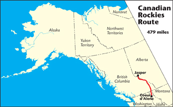
The Canadian Rockies Route connects Coeur d’Alene, ID, to Jasper, AB.
Length: 479 miles
Routes: U.S. 95, Trans-Canada 1, Canada 93
Road Surface: Paved
Season: Open all year
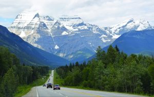
The Canadian Rockies Route begins in Coeur d’Alene, ID, and follows U.S. Highway 95 then BC Highways 3/95 and 93 north to connect with a short portion of Trans-Canada 1. It then heads up the spectacular Icefields Parkway to Jasper, AB, for a total distance of 479 miles/771 km. U.S. Highway 95 runs almost the entire length of Idaho. BC Highways 95/93 take travelers through the tourist destinations of Fairmont Hot Springs, Radium Hot Springs and Kootenay National Park. Canada Highway 93 (the Icefields Parkway) is one of the most scenic drives in North America, traversing Alberta’s Banff and Jasper national parks in the central Canadian Rockies.
Reservations are strongly recommended for camping and lodging along this route in summer because this route is so popular. For campsite reservations in Canadian national parks, go to https://reservation.pc.gc.ca. Most Canadian national park campgrounds are open from May through September.
From Jasper, northbound travelers may drive 45 miles/72 km east via Yellowhead Highway 16 and take the Bighorn Route 204 miles/329 km to Grande Prairie, then join the East Access Route for the 81-mile/131-km drive to Dawson Creek, BC, and the start of the Alaska Highway. Total driving distance from Jasper to Dawson Creek via this route is 330 miles/532 km. Or drive 234 miles/377 km west from Jasper via Yellowhead Highway 16 to Prince George, BC, and join the West Access Route to Dawson Creek, BC, via the 245-mile/395-km Hart Highway. Total driving distance via this route is 479 miles/772 km.
Map (1 detailed pdf file available):
Coeur d’Alene, ID, to Jasper, AB
Communities
The MILEPOST® Quick Reference Log
Miles from Coeur d’Alene (CR) shown.
CR 0 COEUR D’ALENE (pop. 50,665); all services. Northbound travelers head north on Interstate 5.
CR 4 Traffic light at Hayden Avenue; Exxon gas station. HAYDEN (pop. 14,344) city center to east; food, gas, lodging.
CR 15.5 Exit 446 to Silverwood Theme Park and Boulder Beach Water Parkon west side of highway, Silverwood parking lot and RV park on east side of highway; a turn-of-the-century Victorian town with live entertainment, restaurants and rides. Silverwood RV Park is open from early May through October, with 126 full-hookup sites and 41 tent sites.
CR 18.5 Exit 449 to ATHOL (pop. 427); hardware and food stores at exit. Junction with Idaho Highway 54 west to Spirit Lake and Twin Lakes resort areas and east to Bayview and Farragut State Park on Lake Pend Orville.
CR 35.8 Turnoff to Round Lake State Park, 2 miles west on Dufort Road. The 142-acre state park, which surrounds a small lake, has 16 serviced sites, 35 standard (2 handicap accessible); trailers limited to 24 feet. Facilities include a boat launch, boat rentals, grills, sani-dump, firepits, flush toilets, showers.
CR 44 Turnoff for SANDPOINT (pop. 8,390); all visitor services, including major chain hotels/motels and restaurants/fast-food outlets. Visitor Information. Sandpoint is located at the north end of Lake Pend Oreille.
CR 76 BONNERS FERRY (pop. 2,637); all services. Bonners Ferry is a mecca for wildlife photographers, with wildlife viewing at Kootenai National Wildlife Refuge, 5 miles west from downtown’s Kootenai River bridge.
CR 109.5 Moyie River bridge. EASTPORT (pop. 64; elev. 2,580 feet), U.S. Customs and Border Protection; open 24 hours, 7 days a week; phone 208-267- 3966. U.S.–Canada international boundary. Crossing the Pacific–Mountain time zone line. Turn your watch forward 1 hour if you are headed north; back 1 hour if you are headed south.
CR 109.7 Kingsgate Canada border station; open 24 hours, 7 days a week; phone 204-983-3500. U.S.–Canada international boundary. Cross- ing the Pacific–Mountain time zone line.
CR 119 Turnoff for Yahk Provincial Park on the Moyie River; 26 campsites, picnic area adjacent river. Camping fee $21; park is open mid-May through September.
CR 160 Turnoff for downtown CRANBROOK (pop. 19,319). Cranbrook is the main shopping and distribution center for the East Kootenays. Accommodations, services and shopping facilities are available here, either along the highway through town or in the town center.
CR 229 Fairmont Hot Springs, a resort community with food, gas, lodging, camping and post office. Fairmont Hot Springs Resort (phone 250-345-6070 or 1-800-663-4979) offers lodging, an RV park, restaurants, hot mineral pools, 3 golf courses, and many other amenities.
CR 252 Entering RADIUM HOT SPRINGS (pop. 776). This resort community spreads out alongside the highway, offering an array of restaurants, motel and resort accommodations, gas stations and other services. Chief attractions include the hot mineral pool complex—Radium Hot Springs—operated by Parks Canada; river rafting on the Kootenay and Kicking Horse rivers; ziplining on Valley Zipline’s 7-line course; and skiing nearby Panorama Mountain in winter. The hot springs facility is open daily, year-round; toll-free phone 1-800-767-1611; www.hotsprings.ca.
-

Entrance to Kootenay National Park.
CR 253 Kootenay National Park entrance gate for northbound travelers. National Park pass required for Banff, Jasper, Yoho and Kootenay; fee charged.
CR 254.1 Radium Hot Springs; outdoor hot mineral pool, swimming pool, plunge pool, spa. Parking for cars, RVs and motorcoaches in main parking lot. Pools open daily year-round; seasonal hours.
CR 270 McLeod Meadows Kootenay National Park picnic area and campground (reservations).
CR 307.8 Marble Canyon Kootenay National Park campground (reservations).
CR 318.6 Castle Junction. Junction of Trans-Canada Highway 1 and BC Highway 93.
CR 334.6 Exit south to LAKE LOUISE (pop. 1,500), a popular destination resort serving summer tourists and winter skiers. Visitor Information. Food, gas/diesel, lodging, and shopping. Camping at Lake Louise Banff National Park campground (reservations).
CR 336.5 Junction of Trans–Canada Highway 1 with Highway 93 North (Icefields Parkway).
CR 351 Mosquito Creek Banff National Park campground.
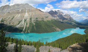
CR 361.4 Bow Summit, elev. 2,088m/6,849 feet; the highest point on the Icefield’s Parkway. Short paved side road west to Peyto Lake viewpoint.
CR 368.2 Silverhorn Banff National Park campground.
CR 371.4 Waterfowl Lake Banff National Park campground.
CR 383.8 Saskatchewan Crossing. The Crossing Resort (seasonal) offers dining (restaurant, cafe, pub), lodging, service station (gas, diesel, propane, sani-dump) and overnight RV parking; phone 403-761-7000.
CR 391.4 Rampark Creek Banff National Park campground.
CR 412.8 Wilcox Creek Jasper National Park campground.
CR 413.8 Icefield Jasper National Park campground; tents only.
CR 414.5 Columbia Icefield Discovery Center on east side of highway features Parks Canada interpretive displays as well as information services, gift shop and restrooms. Food services include a restaurant and cafeteria. Icefields Center Jasper National Park RV campground.
CR 414.6 Athabasca Glacier trail access and parking.
CR 418.3 Columbia Icefield Skywalk to west; no public parking, no public access without a ticket. The Skywalk is a glass-floored observation platform 280m/918 feet above the Sunwapta Valley. Tickets at and shuttle service from Columbia Icefield Discovery Center.
CR 431.2 Jonas Creek Jasper National Park campground.

CR 445 Sunwapta Falls Rocky Mountain Lodge to west at turnoff for Sunwapta Falls. Sunwapta Falls viewpoint and picnic area is 1 km/0.6 mile west via paved road; parking, toilets, and short walk to falls at end of access road.
CR 447.3 Honeymoon Lake Jasper National Park campground.
CR 457.2 Mount Kerkeslin Jasper National Park campground.
CR 459.5 Junction with south end of Highway 93A; access to Athabasca Falls.
CR 474.4 Junction with Highway 93A. Turn west here for access to Marmot Basin ski area access road (turnoff 1.5 miles/2.4 km); Edith Cavell parking (3.2 miles/5.1 km) and Wabasso Jasper National Park Campground (5.6 miles/9 km).
CR 476.4 Wapiti Jasper National Park campground.
CR 477.5 Turnoff to west for Whistlers Jasper National Park campground and Jasper Skytram.
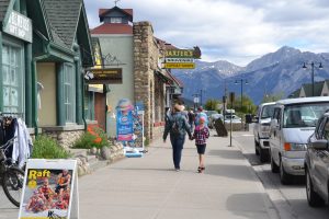
CR 478.5 Traffic light at junction of Highway 93 and Yellowhead Highway 16. Continue 0.8 mile/1.3 km north across Highway 16 via Connaught Drive for downtown JASPER (pop. 5,236). Visitor Information: Jasper National Park Information Center, open year-round.
A year-round international tourist destination, Jasper offers accommodations ranging from bungalows to luxury lodges like the Fairmont Jasper Park Lodge. A wide variety of places to eat and drink in town, including Jasper Brewing Co., the first brewery to open within a Canadian national park. There is also plenty of shopping in the compact, pedestrian-friendly town center.
Public parking for cars and RVs avail- able along Connaught Drive. There is a dedicated RV/trailer parking lot on Hazel Avenue between Connaught Drive and Yellowhead Highway 16.